This article needs additional citations for verification. (December 2009) |
Summerland | |
|---|---|
| The Corporation of the District of Summerland[1] | |
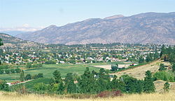
 View of Summerland in 2006 | |
| Nickname: Town of Festivals | |
| Coordinates: 49°36′02″N 119°40′40″W / 49.60056°N 119.67778°W | |
| Country | Canada |
| Province | British Columbia |
| Region | South Okanagan |
| Regional District | Okanagan-Similkameen |
| Founded | 1902 |
| Government | |
| • Mayor | Doug Holmes |
| Area | |
| • Total | 74.08 km2 (28.60 sq mi) |
| • Population Centre | 11.69 km2 (4.51 sq mi) |
| Elevation | 454 m (1,490 ft) |
| Population | |
| • Total | 11,615 |
| • Density | 156.8/km2 (406/sq mi) |
| • Population Centre | 8,742 |
| • Population Centre density | 748.1/km2 (1,938/sq mi) |
| Postal code | V0H |
| Area code(s) | 250, 778, 236 and 672 |
| Website | www |
| Year | Pop. | ±% |
|---|---|---|
| 1921 | 1,892 | — |
| 1931 | 1,791 | −5.3% |
| 1941 | 2,054 | +14.7% |
| 1951 | 3,567 | +73.7% |
| 1956 | 3,893 | +9.1% |
| 1961 | 4,307 | +10.6% |
| 1966 | 4,585 | +6.5% |
| 1971 | 5,551 | +21.1% |
| 1976 | 6,724 | +21.1% |
| 1981 | 7,473 | +11.1% |
| 1986 | 7,755 | +3.8% |
| 1991 | 9,253 | +19.3% |
| 1996 | 10,584 | +14.4% |
| 2001 | 10,713 | +1.2% |
| 2006 | 10,828 | +1.1% |
| 2011 | 11,280 | +4.2% |
| 2016 | 11,615 | +3.0% |
| Sources: Statistics Canada[4] | ||
Summerland is a district municipality on the west side of Okanagan Lake in the interior of British Columbia, Canada. The district is between Peachland to the north and Penticton to the south. The largest centre in the region is Kelowna, approximately 50 km (31 mi) to the north (via Highway 97), and Vancouver is approximately 425 km (264 mi) away to the west. The district is famous for "Bottleneck drive", a system of roads connecting various wineries.
- ^ "British Columbia Regional Districts, Municipalities, Corporate Name, Date of Incorporation and Postal Address" (XLS). British Columbia Ministry of Communities, Sport and Cultural Development. Retrieved 2 November 2014.
- ^ a b Cite error: The named reference
2016popwas invoked but never defined (see the help page). - ^ a b "Census Profile, 2016 Census Summerland [Population centre], British Columbia and British Columbia [Province]". Statistics Canada. Retrieved 18 January 2020.
- ^ "Historical Municipal Census Data: 1921–2011". BC Stats. Retrieved 25 August 2013.


