Sumner County | |
|---|---|
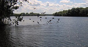
 Old Hickory Lake at Bledsoe Creek State Park | |
 Location within the U.S. state of Tennessee | |
 Tennessee's location within the U.S. | |
| Coordinates: 36°28′N 86°28′W / 36.47°N 86.46°W | |
| Country | |
| State | |
| Founded | November 1786 |
| Named for | Jethro Sumner[1] |
| Seat | Gallatin |
| Largest city | Hendersonville |
| Area | |
| • Total | 543 sq mi (1,410 km2) |
| • Land | 529 sq mi (1,370 km2) |
| • Water | 14 sq mi (40 km2) 2.5% |
| Population (2020) | |
| • Total | 196,281 |
| • Estimate (2023) | 207,994 |
| • Density | 360/sq mi (140/km2) |
| Congressional district | 6th |
| Website | www |
Sumner County is a county located on the central northern border of Tennessee in the United States. As of the 2020 United States Census, the population was 196,281.[2] Its county seat is Gallatin, and its most populous city is Hendersonville.[3] The county is named after an American Revolutionary War hero, General Jethro Sumner.
Sumner County is part of the Nashville-Davidson–Murfreesboro–Franklin, TN Metropolitan Statistical Area. The county is made up of eight cities, including Gallatin, Goodlettsville, Hendersonville, Millersville, Mitchellville, Portland, Westmoreland, and White House. Sumner County is 25 miles (40 km) northeast of Nashville, Tennessee.
- ^ Dee Gee Lester, "Sumner County," Tennessee Encyclopedia of History and Culture. Retrieved: April 7, 2013.
- ^ "State & County QuickFacts". United States Census Bureau. Retrieved December 7, 2013.
- ^ "Find a County". National Association of Counties. Archived from the original on March 2, 2011. Retrieved June 7, 2011.

