| Nanda Devi East | |
|---|---|
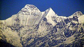
 Nanda Devi East (rightmost peak) | |
| Highest point | |
| Elevation | 7,434 m (24,390 ft)[1] list of highest mountains |
| Prominence | 260 m (850 ft)[2][3] |
| Coordinates | 30°22′00″N 79°59′40″E / 30.36667°N 79.99444°E[1][4] |
| Geography | |
| Location | Chamoli District, Uttarakhand, India |
| Parent range | Garhwal Himalaya |
| Climbing | |
| First ascent | 1939 by Jakub Bujak and Janusz Klarner.[5] |
| Easiest route | South ridge, from Lawan Gad via Longstaff Col: technical rock/snow/ice climb |
Nanda Devi East, locally known as Sunanda Devi, is the lower of the two adjacent peaks of the highest mountain in Uttarakhand and second highest mountain in India; Nanda Devi is its higher twin peak. Nanda Devi and Nanda Devi East are part of the Garhwal Himalaya, and are located in the state of Uttarakhand. The two peaks are visible from almost everywhere in Kumaon. The first ascent of Nanda Devi East peak was probably in 1939 by Jakub Bujak and Janusz Klarner. The elevation of Nanda Devi East is 7,434 m (24,390 ft) and its prominence is 260 m (850 ft).
- ^ a b "High Asia I: The Karakoram, Pakistan Himalaya and India Himalaya (north of Nepal)". Peaklist.org. Retrieved 28 May 2014.
- ^ Corrected DEM files for the Himalaya
- ^ Garhwal-Himalaya-Ost, 1:150,000 scale topographic map, prepared in 1992 by Ernst Huber for the Swiss Foundation for Alpine Research, based on maps of the Survey of India.
- ^ The Himalayan Index gives the coordinates of Nanda Devi as 30°22′12″N 79°58′12″E / 30.37000°N 79.97000°E.
- ^ Harish Kapadia, "Nanda Devi", in World Mountaineering, Audrey Salkeld, editor, Bulfinch Press, 1998, ISBN 0-8212-2502-2, pp. 254–257.
