Sur Baher
| |
|---|---|
| Hebrew transcription(s) | |
| • Also spelled | Tsur Baher (unofficial) |
 Sur Baher | |
Location of Sur Baher within Palestine | |
| Coordinates: 31°44′14″N 35°13′59″E / 31.73722°N 35.23306°E | |
| Grid position | 172/127 PAL |
| Jerusalem Municipality | Jerusalem |
| Population (2006) | |
| • Total | 15,000 |
| Name meaning | The wall of Bahir (Prominent)[1] |

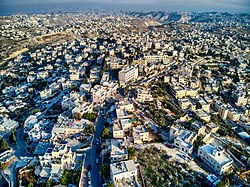
Sur Baher (Arabic: صور باهر, Hebrew: צור באהר), also Tsur Baher, is a Palestinian neighborhood on the southeastern outskirts of East Jerusalem. It is located east of Ramat Rachel and northeast of Har Homa. In 2006, Sur Baher had a population of 15,000.[2]
