Surry County | |
|---|---|
 | |
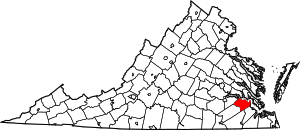
 Location within the U.S. state of Virginia | |
 Virginia's location within the U.S. | |
| Coordinates: 37°07′01″N 76°53′18″W / 37.11691°N 76.88831°W | |
| Country | |
| State | |
| Founded | 1652 |
| Named for | Surrey |
| Seat | Surry |
| Largest town | Claremont |
| Area | |
| • Total | 310 sq mi (800 km2) |
| • Land | 279 sq mi (720 km2) |
| • Water | 31 sq mi (80 km2) 10.1% |
| Population (2020) | |
| • Total | 6,561 |
| • Density | 21/sq mi (8.2/km2) |
| Time zone | UTC−5 (Eastern) |
| • Summer (DST) | UTC−4 (EDT) |
| Congressional district | 4th |
| Website | www |
Surry County is a county in the southeastern part of the Commonwealth of Virginia. As of the 2020 census, the population was 6,561.[1]
In 1652, Surry County was formed from the portion of James City County south of the James River. For more than 350 years it has depended on an agricultural economy.[citation needed] The county has 19 sites listed on the National Register, including a landmark occupied in 1676 known as Bacon's Castle and Chippokes Plantation (now a state park). The Jamestown Ferry provides easy access to Virginia's Historic Triangle, featuring Jamestown, Williamsburg, and Yorktown, linked by the National Park Service's Colonial Parkway.[citation needed]
The county is known for farming, curing Virginia Hams, and harvesting lumber, notably Virginia pine.
- ^ "Surry County, Virginia". United States Census Bureau. Retrieved January 30, 2022.
