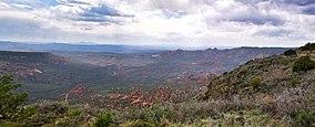
| Sycamore Canyon Wilderness | |
|---|---|
 | |
| Location | Coconino and Yavapai counties, Arizona, United States |
| Nearest city | Clarkdale |
| Coordinates | 34°59′17″N 111°59′18″W / 34.98806°N 111.98833°W |
| Area | 55,937 acres (22,637 ha) |
| Established | 1972 |
| Governing body | U.S. Forest Service |

Sycamore Canyon Wilderness is a 56,000-acre (22,662 ha) wilderness area in the Coconino, Kaibab and Prescott national forests in the U.S. state of Arizona.[1] Encompassing Sycamore Canyon and its surrounds from south of Williams to the confluence of Sycamore Creek with the Verde River, the wilderness is about 40 miles (64 km) southwest of Flagstaff.[2] The canyon is one of several in Arizona that cut through the Mogollon Rim.[1] Relevant United States Geological Survey (USGS) map quadrangles are Davenport Hill, White Horse Lake, May Tank Pocket, Perkinsville, Sycamore Basin, and Clarkdale.[3] Red Rock-Secret Mountain Wilderness borders Sycamore Canyon Wilderness on the east.[1]
Ring-tailed cats, black bears, mountain lions, elk, deer, rattlesnakes, scorpions, canyon wrens, hermit thrushes, and many other creatures frequent the wilderness. Vegetation, which varies with elevation and the availability of water, includes stands of pine, fir, sycamore, walnut, and cottonwood.[1] The canyon walls include exposures of red sandstone, white limestone, and brown lava.[1] Parts of the wilderness are open for dispersed camping; many trails are open for horseback riding as well as hiking.[2]
- ^ a b c d e Wilderness Institute. "Sycamore Canyon Wilderness". University of Montana. Retrieved April 24, 2013.
- ^ a b "Sycamore Canyon Wilderness". U.S. Forest Service. Retrieved April 23, 2013.
- ^ "Sycamore Canyon Wilderness". Geographic Names Information System. United States Geological Survey. February 8, 1980. Retrieved April 23, 2013.

