| Sydenham Sydney, New South Wales | |||||||||||||||
|---|---|---|---|---|---|---|---|---|---|---|---|---|---|---|---|
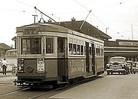
 R class tram no 1923 at Sydenham railway station, 20 November 1954. Trams in Sydney services | |||||||||||||||
 | |||||||||||||||
| Coordinates | 33°55′4″S 151°10′4″E / 33.91778°S 151.16778°E | ||||||||||||||
| Population | 1,100 (SAL 2021)[1] | ||||||||||||||
| Postcode(s) | 2044 | ||||||||||||||
| Elevation | 9 m (30 ft) | ||||||||||||||
| Location | 8 km (5 mi) south of Sydney CBD | ||||||||||||||
| LGA(s) | Inner West Council | ||||||||||||||
| State electorate(s) | Heffron | ||||||||||||||
| Federal division(s) | Grayndler | ||||||||||||||
| |||||||||||||||


Sydenham is a suburb in the Inner West[2] of Sydney, in the state of New South Wales, Australia. Sydenham is located 8 kilometres south of Sydney central business district and is part of the local government area of Inner West Council. Sydenham is surrounded by the suburbs of Marrickville, St Peters and Tempe.
- ^ Australian Bureau of Statistics (28 June 2022). "Sydenham (NSW) (suburb and locality)". Australian Census 2021 QuickStats. Retrieved 28 June 2022.
- ^ Australian Suburb Guide: Sydney Inner West Archived 26 December 2012 at the Wayback Machine. Retrieved 7 August 2013.
