Tabaco | |
|---|---|
| City of Tabaco | |
 Tabaco Park and municipal hall in the background | |
| Nickname: City of Love | |
| Anthem: Tabaco City Hymn | |
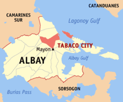
 Map of Albay with Tabaco highlighted | |
Location within the Philippines | |
| Coordinates: 13°21′N 123°44′E / 13.35°N 123.73°E | |
| Country | Philippines |
| Region | Bicol Region |
| Province | Albay |
| District | 1st district |
| Founded | 1731 |
| Cityhood | March 24, 2001 |
| Barangays | 47 (see Barangays) |
| Government | |
| • Type | Sangguniang Panlungsod |
| • Mayor | Cielo Krisel Lagman-Luistro[1] |
| • Vice Mayor | Nestor San Pablo[1] |
| • Representative | Edcel Lagman |
| • City Council | Members |
| • Electorate | 80,465 voters (2022) |
| Area | |
| • Total | 117.45 km2 (45.35 sq mi) |
| Elevation | 168 m (551 ft) |
| Highest elevation | 2,444 m (8,018 ft) |
| Lowest elevation | 0 m (0 ft) |
| Population (2020 census)[4] | |
| • Total | 140,961 |
| • Density | 1,200/km2 (3,100/sq mi) |
| • Households | 31,415 |
| Economy | |
| • Income class | 4th city income class |
| • Poverty incidence | 20.21 |
| • Revenue | ₱ 731.2 million (2020), 340.2 million (2012), 359.5 million (2013) |
| • Assets | ₱ 2,692 million (2020), 1,172 million (2012), 1,196 million (2013) |
| • Expenditure | ₱ 551.6 million (2020) |
| • Liabilities | ₱ 653.7 million (2020), 228.7 million (2012), 194.7 million (2013) |
| Service provider | |
| • Electricity | Albay Electric Cooperative inc (ALECO) |
| Time zone | UTC+8 (PST) |
| ZIP code | 4511 |
| PSGC | |
| IDD : area code | +63 (0)52 |
| Native languages | Central Bikol Tagalog |
| Website | www |
Tabaco, officially the City of Tabaco (Central Bikol: Syudad kan Tabaco; Filipino: Lungsod ng Tabaco), is a 4th class component city in the province of Albay, Philippines. According to the 2020 census, it has a population of 140,961 people.[4]
It is one of the three component cities of the province, along with Legazpi and Ligao. The mainland part of the city is bordered by the town of Malinao to the north, the towns of Polangui and Oas to the west, Ligao to the southwest, Malilipot town to the southeast, and Lagonoy Gulf to the east.[6] The symmetric Mayon Volcano, the most active volcano in the Philippines, lies south of the city. Tabaco is one of the eight towns and cities that share jurisdiction on the volcano, dividing the peak like slices of a pie when viewed from above.
The island of San Miguel, the westernmost of the four main islands in Lagonoy Gulf, falls under the jurisdiction of Tabaco. Five of the barangays of the city are located on the island for a total of 47 barangays composing the city.[7]
- ^ a b "Halalan 2022 CITY OF TABACO, ALBAY Election Results". abs-cbn.com. Retrieved May 14, 2024.
- ^ City of Tabaco | (DILG)
- ^ "2015 Census of Population, Report No. 3 – Population, Land Area, and Population Density" (PDF). Philippine Statistics Authority. Quezon City, Philippines. August 2016. ISSN 0117-1453. Archived (PDF) from the original on May 25, 2021. Retrieved July 16, 2021.
- ^ a b Census of Population (2020). "Region V (Bicol Region)". Total Population by Province, City, Municipality and Barangay. Philippine Statistics Authority. Retrieved July 8, 2021.
- ^ "PSA Releases the 2021 City and Municipal Level Poverty Estimates". Philippine Statistics Authority. April 2, 2024. Retrieved April 28, 2024.
- ^ Cite error: The named reference
Fortunewas invoked but never defined (see the help page). - ^ "City of Tabaco" Archived May 27, 2012, at the Wayback Machine. PSGC Interactive of National Statistical Coordination Board. Retrieved on April 20, 2012.


