Tachiarai
大刀洗町 | |
|---|---|
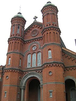
 Imamura Catholic Church | |
 Location of Tachiarai in Fukuoka Prefecture | |
 | |
| Coordinates: 33°22′20″N 130°37′21″E / 33.37222°N 130.62250°E | |
| Country | Japan |
| Region | Kyushu |
| Prefecture | Fukuoka |
| District | Mii |
| Area | |
| • Total | 22.84 km2 (8.82 sq mi) |
| Population (January 31, 2024) | |
| • Total | 16,065 |
| • Density | 700/km2 (1,800/sq mi) |
| Time zone | UTC+09:00 (JST) |
| City hall address | 819 Tomita, Tachiarai-machi, Mii-gun, Fukuoka-ken 830-1298 |
| Website | Official website |
| Symbols | |
| Bird | Skylark |
| Flower | Cherry blossom |
| Tree | Ilex integra |

Tachiarai (大刀洗町, Tachiarai-machi) is a town located in Mii District, Fukuoka Prefecture, Japan. As of 31 January 2024[update], the town had an estimated population of 16,065 in 6283 households, and a population density of 700 persons per km². [1] The total area of the town is 22.84 km2 (8.82 sq mi).
- ^ "Tachiarai Town official statistics" (in Japanese). Japan.


