Tai Po New Town
大埔新市鎮 | |
|---|---|
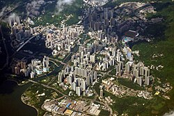
 Aerial view of Tai Po New Town | |
| Etymology: name after the historic market town Tai Po Market | |
| Nickname: Tai Po | |
| Coordinates: 22°26′41″N 114°10′14″E / 22.4446°N 114.1706°E | |
| Country | China |
| Provincial-level SARs | Hong Kong |
| Regions | The New Territories |
| District | Tai Po District |
| Time zone | UTC+8 |
| Tai Po New Town | |||||||||||||
|---|---|---|---|---|---|---|---|---|---|---|---|---|---|
| Traditional Chinese | 大埔新市鎮 | ||||||||||||
| Simplified Chinese | 大埔新市镇 | ||||||||||||
| |||||||||||||
| Tai Po Town | |||||||||||||
| Chinese | 大埔市 | ||||||||||||
| |||||||||||||
Tai Po New Town, or Tai Po Town (Chinese: 大埔新市鎮), is a new town (satellite town) and non-administrative area in Tai Po District, in the New Territories, Hong Kong. The area is a planned town that surrounding the existing indigenous market towns of Tai Po Hui (literally Tai Po Market, also known as Tai Wo Shi in the 1900s) and Tai Po Kau Hui (Tai Po Old Market), as well as east of the existing indigenous villages that located on the Lam Tsuen Valley as well as west of those villages in Ting Kok and Tai Mei Tuk and south of those villages in Nam Hang, Fung Yuen and Sha Lo Tung. Most of the lands of the new town were obtained by land reclamation. In the present day, Tai Po New Town is simply known as Tai Po.[1]: 227 The new town is largely covered by the government Tai Po Outline Zoning Plan, which legally regulates the land use of the area, on top of the terms in the land lease contract with the government. Some of the land lease within the area, were known as Tai Po Town Lot № foo. In elections, the town has a different zoning scheme for the election constituencies.
- ^ 萬里地圖製作中心, ed. (2016). 香港大地圖 [Complete City Guide of Hong Kong] (in Chinese (Hong Kong)) (2017 ed.). Wan Li Book (Sino United Publishing Group). ISBN 9789621460318. Retrieved 25 December 2018.
