Takahata
高畠町 | |
|---|---|
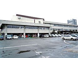
 Takahata Town Hall | |
 Location of Takahata in Yamagata Prefecture | |
| Coordinates: 38°00′9.9″N 140°11′20.7″E / 38.002750°N 140.189083°E | |
| Country | Japan |
| Region | Tōhoku |
| Prefecture | Yamagata |
| District | Higashiokitama |
| Area | |
| • Total | 180.26 km2 (69.60 sq mi) |
| Population (April 2019) | |
| • Total | 23,367 |
| • Density | 130/km2 (340/sq mi) |
| Time zone | UTC+9 (Japan Standard Time) |
| Phone number | 0238-52-1111 |
| Address | 436-banchi Takahata, Takahata-machi, Higashiokitama-gun, Yamagata-ken 992-0392 |
| Climate | Cfa/Dfa |
| Website | Official website |
| Symbols | |
| Flower | Azalea |
| Tree | Japanese Red Pine |

Takahata (高畠町, Takahata-machi) is a town located in Yamagata Prefecture, Japan. As of 1 April 2019[update], the town had an estimated population of 23,367, in 7629 households,[1] and a population density of 130 persons per km2. The total area of the town is 180.26 square kilometres (70 sq mi).
- ^ Takahata Town official statistics (in Japanese)


