Takamatua | |
|---|---|
 Takamatua Bay | |
 | |
| Coordinates: 43°47′0″S 172°58′15″E / 43.78333°S 172.97083°E | |
| Country | New Zealand |
| Region | Canterbury Region |
| District | Christchurch City |
| Ward | Banks Peninsula |
| Community | Te Pātaka o Rākaihautū Banks Peninsula |
| Electorates |
|
| Government | |
| • Territorial Authority | Christchurch City Council |
| • Regional council | Environment Canterbury |
| • Mayor of Christchurch | Phil Mauger |
| • Banks Peninsula MP | Vanessa Weenink |
| • Te Tai Tonga MP | Tākuta Ferris |
| Area | |
| • Total | 6.30 km2 (2.43 sq mi) |
| Population (June 2024)[2] | |
| • Total | 110 |
| • Density | 17/km2 (45/sq mi) |
| Postcode | 7581 |
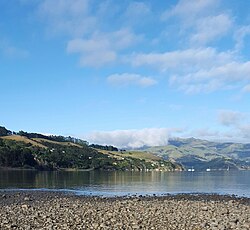
Takamatua, with an initial European name of German Bay, is a small town situated in Akaroa Harbour on Banks Peninsula in New Zealand. The main road to Akaroa (State Highway 75) passes through this locality. It is 3 kilometres (1.9 mi) north of Akaroa township.[3]
- ^ Cite error: The named reference
Areawas invoked but never defined (see the help page). - ^ "Aotearoa Data Explorer". Statistics New Zealand. Retrieved 26 October 2024.
- ^ Reed New Zealand atlas (2004) Auckland: Reed Publishing. Map 83. ISBN 0 7900 0952 8