Native name: Japanese: 竹島 | |
|---|---|
 Takeshima Island Kagoshima Prefecture Aerial photograph.1977 | |
 | |
| Geography | |
| Location | East China Sea |
| Coordinates | 30°48′50″N 130°25′2.1″E / 30.81389°N 130.417250°E |
| Archipelago | Ōsumi Islands |
| Area | 4.2 km2 (1.6 sq mi) |
| Coastline | 12.8 km (7.95 mi) |
| Highest elevation | 220 m (720 ft) |
| Highest point | Magomeyama |
| Administration | |
Japan | |
| Kagoshima | |
| Demographics | |
| Population | 78 (2010) |
| Pop. density | 18.57/km2 (48.1/sq mi) |
| Ethnic groups | Japanese |
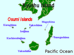
Takeshima (竹島), is one of the Ryukyu Islands, usually classed with the Ōsumi Islands belonging to Kagoshima Prefecture, Japan. The island, 4.2 km2 in area, has a population of 78 persons. The island can only be reached by ferry service to the city of Kagoshima on the mainland, as there is no airport. Travel time is about 3 hours. The islanders are dependent mainly on fishing, agriculture and seasonal tourism.