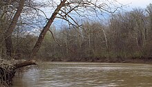

The Tallahatchie River is a river in Mississippi which flows 230 miles (370 km)[1] from Tippah County, through Tallahatchie County, to Leflore County, where it joins the Yalobusha River to form the Yazoo River,[2][3] which ultimately meets the Mississippi River at Vicksburg, Mississippi. The river is navigable for about 100 miles (160 km).[4] At Money, Mississippi, the river's flow measures approximately 7,861 cubic feet per second.[5]
Tallahatchie is a Choctaw name meaning "rock of waters."[6] The sources of the Tallahatchie River have outcrops of iron sandstone.[7]
As part of the Flood Control Act of 1936, the federal government built an earth-filled flood control dam on the Tallahatchie near the town of Sardis, Mississippi, creating Sardis Lake.
- ^ Hopkins, Daniel J., editor (1997). Merriam-Webster's Geographical Dictionary. (Third Edition). Springfield, MA: Merriam-Webster, Inc. Publishers. p.1155.ISBN 0-87779-546-0
- ^ "The National Map". U.S. Geological Survey. Retrieved Feb 9, 2011.
- ^ "Tallahatchie River". Geographic Names Information System. United States Geological Survey, United States Department of the Interior.
- ^ Hopkins. Merriam-Webster's Geographical Dictionary.
- ^ "USGS Surface Water data for Mississippi: USGS Surface-Water Annual Statistics".
- ^ Stafford, James Douglas. (16 November 1975). "The Way of the River". The Commercial Appeal. Mid-South Magazine. (Memphis, Tennessee).
- ^ Rowland, Dunbar. (1925). History of Mississippi: the Heart of the South. 1. Chicago, IL-Jackson, MS: S.J. Clarke Publishing Co. pp. 38-39.