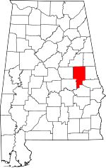
Tallapoosa County | |
|---|---|
 Tallapoosa County Courthouse in Dadeville | |
 Location within the U.S. state of Alabama | |
 Alabama's location within the U.S. | |
| Coordinates: 32°51′41″N 85°47′50″W / 32.8614°N 85.7972°W | |
| Country | |
| State | |
| Founded | December 18, 1832[1] |
| Named for | Tallapoosa River |
| Seat | Dadeville |
| Largest city | Alexander City |
| Area | |
| • Total | 766 sq mi (1,980 km2) |
| • Land | 717 sq mi (1,860 km2) |
| • Water | 50 sq mi (100 km2) 6.5% |
| Population (2020) | |
| • Total | 41,311 |
| • Estimate (2023) | 40,677 |
| • Density | 54/sq mi (21/km2) |
| Time zone | UTC−6 (Central) |
| • Summer (DST) | UTC−5 (CDT) |
| Congressional district | 3rd |
| Website | www |
| |
Tallapoosa County is a county located in the east-central portion of the U.S. state of Alabama.[1] As of the 2020 census, the population was 41,311.[2] Its county seat is Dadeville.[3] Its largest city is Alexander City.
- ^ a b "ACES Tallapoosa County Office" (links/history), Alabama Cooperative Extension System (ACES), 2007, webpage: ACES-Tallapoosa.
- ^ "State & County QuickFacts". United States Census Bureau. Retrieved September 12, 2023.
- ^ "Find a County". National Association of Counties. Retrieved June 7, 2011.
