| Tallebudgera | |
|---|---|
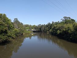
 Waterway at Coplicks Lane in Tallebudgera, 2015 | |
Location of the Tallebudgera Creek mouth in Queensland | |
| Etymology | Aboriginal: good fishing[1] |
| Location | |
| Country | Australia |
| State | Queensland |
| Region | South East Queensland |
| Local government area | City of Gold Coast |
| Physical characteristics | |
| Source | Springbrook Plateau |
| • location | Upper Tallebudgera |
| • coordinates | 28°13′13″S 153°19′10″E / 28.22028°S 153.31944°E |
| • elevation | 100 m (330 ft) |
| Mouth | Burleigh Head |
• location | Palm Beach |
• coordinates | 28°5′35″S 153°27′44″E / 28.09306°S 153.46222°E |
• elevation | 0 m (0 ft) |
| Length | 25 km (16 mi) |
| Basin size | 98 km2 (38 sq mi) |
| Basin features | |
| Tributaries | |
| • right | Mount Cougal Creek |
| National park | Springbrook National Park |
| [2][3] | |
Tallebudgera Creek is a creek in South East Queensland, Australia. Its catchment lies within the Gold Coast local government area and covers an area of 98 square kilometres (38 sq mi). The river is approximately 25 kilometres (16 mi) in length and is known for good fishing.
- ^ "Tallebudgera Creek". Visit Gold Coast. Gold Coast Tourism. 2015. Retrieved 28 September 2015.
- ^ "Map of Tallebudgera Creek, QLD". Bonzle Digital Atlas of Australia. Retrieved 28 September 2015.
- ^ "Tallebudgera Creek Catchment". City of Gold Coast. Retrieved 28 September 2015.
