Tamanrasset District
دائرة تمنراست | |
|---|---|
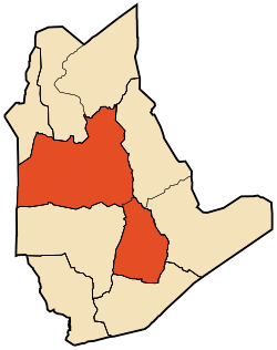
 Map of Tamanrasset District | |
| Coordinates: 22°47′N 5°31′E / 22.783°N 5.517°E | |
| Country | |
| Province | Tamanrasset |
| District seat | Tamanrasset |
| Area | |
| • Total | 131,151 km2 (50,638 sq mi) |
| Population (2008)[1] | |
| • Total | 96,843 |
| • Density | 0.74/km2 (1.9/sq mi) |
| Time zone | UTC+01 (CET) |
| Municipalities | 2 |
Tamanrasset is a district in Tamanrasset Province, Algeria. It was named after its capital, Tamanrasset, which is also the capital of the province. With 96,843 people,[1] it is the most populated district in the province (however, the population density is low) and one of the largest districts in the country.
- ^ a b "Population: Wilaya de Tamanrasset" (PDF) (in French). Office National des Statistiques Algérie. Retrieved 30 May 2013.