| Tanana River | |
|---|---|
 Tanana River near Fairbanks, Alaska | |
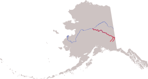
 Course of the Tanana River, formed by the shorter Nabesna River (left) and Chisana River (right), then flowing northwest to meet the Yukon River | |
| Etymology | from the Koyukon (Athabaskan) tene no, tenene, meaning "trail river". |
| Native name |
|
| Location | |
| Country | United States |
| State | Alaska |
| District | Southeast Fairbanks Census Area, Fairbanks North Star Borough, Yukon-Koyukuk Census Area |
| Physical characteristics | |
| Source | confluence of the Nabesna and Chisana rivers |
| • location | Northway Junction, Tetlin National Wildlife Refuge |
| • coordinates | 63°02′57″N 141°51′52″W / 63.04917°N 141.86444°W[1] |
| • elevation | 1,672 ft (510 m)[2] |
| Mouth | Yukon River |
• location | near Tanana |
• coordinates | 65°09′38″N 151°57′37″W / 65.16056°N 151.96028°W[1] |
• elevation | 200 ft (61 m)[1] |
| Length | 584 mi (940 km) |
| Basin size | 44,000 sq mi (110,000 km2)[3] |
| Discharge | |
| • location | mouth[3] |
| • average | 41,800 cu ft/s (1,180 m3/s)[3] |
The Tanana River /ˈtænənɑː/ (Lower Tanana: Tth'eetoo', Upper Tanana: Tth’iitu’ Niign) is a 584-mile (940 km) tributary of the Yukon River in the U.S. state of Alaska.[n 1] According to linguist and anthropologist William Bright, the name is from the Koyukon (Athabaskan) tene no, tenene, literally "trail river".[7]
The river's headwaters are located at the confluence of the Chisana and Nabesna rivers just north of Northway in eastern Alaska.[8] The Tanana flows in a northwest direction from near the border with the Yukon Territory, and laterally along the northern slope of the Alaska Range, roughly paralleled by the Alaska Highway.[8] In central Alaska, it emerges into a lowland marsh region known as the Tanana Valley and passes south of the city of Fairbanks.[8]
In the marsh regions it is joined by several large tributaries, including the Nenana (near the city of Nenana) and the Kantishna. It passes the village of Manley Hot Springs and empties into the Yukon near the town of Tanana.[8]
Ice on the river accumulates each winter to an average maximum thickness of 43 inches (110 cm) at Nenana.[9] The Nenana Ice Classic, begun in 1917, is an annual guessing game about the date of the ice break-up.[9] In October or November, after the freeze has begun, a tripod is planted in ice in the middle of the river. The tripod is connected to an on-shore clock that stops when the tripod begins to move during the spring thaw. Over the years, the break-up date has varied from April 20 to May 20.[9] Betting on the exact time of the break-up takes the form of a lottery, called the Nenana Ice Classic.
- ^ a b c "Tanana River". Geographic Names Information System. United States Geological Survey. January 1, 2000. Retrieved April 28, 2011.
- ^ Source elevation derived from Google Earth search using GNIS source coordinates.
- ^ a b c Benke and Cushing, p. 797
- ^ Kammerer, J.C. (September 1, 2005). "Largest Rivers in the United States". United States Geological Survey. Archived from the original on January 29, 2017. Retrieved April 28, 2011.
- ^ Irwin, Thomas (October 3, 2005). "Recordable Disclaimer of Interest Application for the Nabesna River" (PDF). U.S. Bureau of Land Management. Archived from the original (PDF) on October 19, 2012. Retrieved February 19, 2011.
- ^ Alaska Atlas and Gazetteer (Map) (7th ed.). DeLorme. 2010. p. 98. ISBN 0-89933-289-7.
- ^ Bright, William (2004). Native American placenames of the United States. University of Oklahoma Press. p. 478. ISBN 978-0-8061-3598-4. Retrieved 11 April 2011.
- ^ a b c d Alaska Atlas and Gazetteer (Map) (7th ed.). DeLorme. 2010. pp. 107–09, 112–17, 122. ISBN 0-89933-289-7.
- ^ a b c "Nenana Ice Classic: Tanana River Ice Annual Breakup Dates". National Snow and Ice Data Center. Archived from the original on March 14, 2011. Retrieved April 28, 2011.
Cite error: There are <ref group=n> tags on this page, but the references will not show without a {{reflist|group=n}} template (see the help page).