This article has multiple issues. Please help improve it or discuss these issues on the talk page. (Learn how and when to remove these messages)
|
Tandai | |
|---|---|
Suburb | |
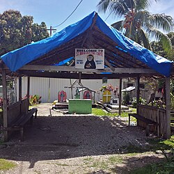
 St. Maria Faus Tina Chapel Tandai. West of Honiara | |
| Coordinates: 9°25′S 159°55′E / 9.417°S 159.917°E | |
| Country | |
| Province | Honiara Town |
| Island | Guadalcanal |
| Elevation | 20 - 100 m (−310 ft) |
| Population (2009) | |
| • Total | 10,837[1] |
| Time zone | UTC+11 (UTC) |
Tandai is a suburb of Honiara, in the Solomon Islands, located 2 kilometres (1.2 mi) west of the main center on the Tandai Highway.[2] Tandai is in the Honiara City Council ward of Nggosi.[3]
Tandai is east of White River and west of Rove.
- ^ 2009 2009 POPULATION & HOUSING CENSUS. "Report on Migration and Urbanisation". Retrieved 26 April 2015.
{{cite web}}: CS1 maint: numeric names: authors list (link) - ^ Geographic Information Unit (June 2004). HONIARA LOCATION GUIDE. Department of Lands and Survey. p. 205.
- ^ Honiara City Council. "Ward Map". Archived from the original on 19 April 2015. Retrieved 19 April 2015.
