Tantura
الطنطورة al-Tantura | |
|---|---|
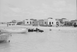
 Tantura (1920-1933) during the British Mandate | |
| Etymology: "The Peak"[1] | |
A series of historical maps of the area around Tantura (click the buttons) | |
Location within Mandatory Palestine | |
| Coordinates: 32°36′34″N 34°55′04″E / 32.60944°N 34.91778°E | |
| Palestine grid | 142/224 |
| Geopolitical entity | Mandatory Palestine |
| Subdistrict | Haifa |
| Date of depopulation | 23 May 1948[3] |
| Area | |
| • Total | 14,250 dunams (14.25 km2 or 5.50 sq mi) |
| Population (1945) | |
| • Total | 1,490[2] |
| Cause(s) of depopulation | Expulsion by Yishuv forces |
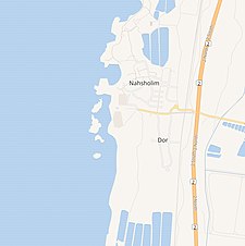
| Current Localities | Nahsholim,[4]Dor[5] |
Tantura (Arabic: الطنطورة, al-Tantura, lit. The Peak; Hebrew and Phoenician: דור, Dor)[6] was a Palestinian Arab fishing village located 8 kilometers (5 mi) northwest of Zikhron Ya'akov[7] on the Mediterranean coast of Israel. Near the village lie the ruins of the ancient Phoenician city of Dor.[8]
The village stood on a low limestone hill overlooking the shoreline of two small bays.[9] The water was supplied from a well in the eastern part of the village.[9] The al-Bab gate was in the southeast of the village. The Roman ruins were on the coast to the north with the hill of Umm Rashid to the south.[10] In 1945 it had a population of 1,490.
The village was targeted in the early stages of the 1948 Arab–Israeli War, with its houses looted and its Arab Palestinian inhabitants expelled and others massacred by the Palmach underground Alexandroni Brigade. The Tantura massacre was first documented by a Palestinian politician in 1951, decades before a 2022 Israeli documentary revealed testimony from several IDF veterans affirming that a massacre, involving somewhere between several to 200 Palestinian victims, had taken place at that time.[11]
- ^ Palmer, 1881, p. 141
- ^ Department of Statistics, 1945, p. 15
- ^ Morris, 2004, p. xvi, village #176. Also gives expulsion as the cause of depopulation
- ^ Morris, 2004; p. xx, settlement #9
- ^ Morris, 2004; p. xxii, settlement #186
- ^ Benvenisti, 2000, p. 50
- ^ "Bashan Foundation.org". Archived from the original on November 22, 2008.
- ^ George Rawlinson, History of Phoenicia, Longmans, Green & Co, 1889 ISBN 978-0-837-01596-5 pp.83-84.
- ^ a b Benvenisti, 2000, p. 135
- ^ Cite error: The named reference
IlanPappewas invoked but never defined (see the help page). - ^ Cite error: The named reference
Raz2022was invoked but never defined (see the help page).


