| Tanunda South Australia | |||||||||||||||
|---|---|---|---|---|---|---|---|---|---|---|---|---|---|---|---|
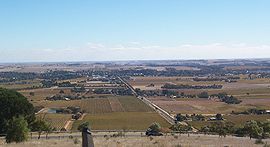
 Looking across the vineyards towards Tanunda from Mengler Hill Lookout | |||||||||||||||
| Coordinates | 34°31′0″S 138°58′0″E / 34.51667°S 138.96667°E | ||||||||||||||
| Population | 4,710 (2021 census) | ||||||||||||||
| Established | 1848 | ||||||||||||||
| Postcode(s) | 5352 | ||||||||||||||
| Location | 69 km (43 mi) North East of Adelaide via | ||||||||||||||
| LGA(s) | Barossa Council | ||||||||||||||
| State electorate(s) | Schubert | ||||||||||||||
| Federal division(s) | Barker | ||||||||||||||
| |||||||||||||||
| Footnotes | [1] | ||||||||||||||
Tanunda is a town situated in the Barossa Valley region of South Australia. In the 2021 census, Tanunda recorded a population of 4,710 people.[2]
- ^ "Property Location Browser (Search: Tanunda, LOCB)". Government of South Australia. Archived from the original on 7 December 2015. Retrieved 5 February 2016.
- ^ Australian Bureau of Statistics (28 June 2022). "Tanunda (Suburb and Locality)". 2021 Census QuickStats. Retrieved 1 June 2024.
