Taoyuan Subdistrict
桃园街道 | |
|---|---|
 Former site of Tientsin Kung Shang College, 2014 | |
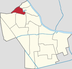
 Location of Taoyuan Subdistrict within Hexi District | |
| Coordinates: 39°06′32″N 117°12′15″E / 39.10889°N 117.20417°E | |
| Country | China |
| Municipality | Tianjin |
| District | Hexi |
| Village-level Divisions | 8 communities |
| Area | |
| • Total | 1.4 km2 (0.5 sq mi) |
| Elevation | 8 m (26 ft) |
| Population (2010) | |
| • Total | 51,061 |
| • Density | 36,000/km2 (94,000/sq mi) |
| Time zone | UTC+8 (China Standard) |
| Postal code | 300202 |
| Area code | 022 |
Taoyuan Subdistrict (simplified Chinese: 桃园街道; traditional Chinese: 桃園街道; pinyin: Táoyuán Jiēdào) is a subdistrict in the northwest of Hexi District, Tianjin. It is located at the southwest of Dayingmen and Xiawafang Subdistricts, north of Yuexiu Road and Machang Subdistricts, and southeast of Xinxing and Wudadao Subdistricts. As of 2010, the population of Taoyuan Subdistrict was 51,061.[1]
The subdistrict was named after Taoyuan (Chinese: 桃园; lit. 'Peach Orchard') Village that used to exist in the region.[2]
- ^ "China: Tiānjīn Municipal Province (Districts and Townships) - Population Statistics, Charts and Map". www.citypopulation.de. Retrieved 2022-11-05.
- ^ Cite error: The named reference
:0was invoked but never defined (see the help page).

