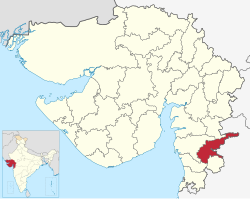
Tapi district | |
|---|---|
 River in Tapi district | |
 Location of district in Gujarat | |
| Coordinates: 21°7′12″N 73°24′0″E / 21.12000°N 73.40000°E | |
| Country | |
| State | Gujarat |
| Headquarters | Vyara |
| Government | |
| • Body | Nagar Palika |
| Area | |
| • Total | 3,139 km2 (1,212 sq mi) |
| Population (2011) | |
| • Total | 807,022 |
| • Density | 260/km2 (670/sq mi) |
| Languages | |
| • Official | Gujarati, Hindi |
| Time zone | UTC+5:30 (IST) |
| Area code(s) | 02624, 02625, 02626, 02628 |
| Vehicle registration | GJ 26 |
| Website | tapi |
Tapi district is one of the 33 districts of Gujarat state in western India. It has seven talukas: Vyara, Songadh, Nizar, Valod, Uchhal, Dolavan and Kukarmunda. Vyara town is the district headquarters. Tapi has 523 villages and two municipalities. The district was formed in 2007 out of some talukas that were separated from Surat district.[1]
- ^ "About Tapi". Government of Gujarat.
