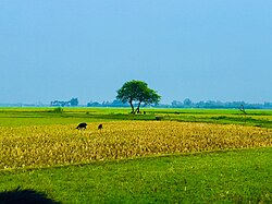
Tarash
তাড়াশ | |
|---|---|
 | |
 | |
| Coordinates: 24°26′N 89°22.5′E / 24.433°N 89.3750°E | |
| Country | |
| Division | Rajshahi |
| District | Sirajganj |
| Area | |
| • Total | 300.07 km2 (115.86 sq mi) |
| Population | |
| • Total | 211,853 |
| • Density | 710/km2 (1,800/sq mi) |
| Time zone | UTC+6 (BST) |
| Area code | 07528[2] |
| Website | Official Map of Tarash |
Tarash[a] is an upazila, or sub-district of Sirajganj District, located in Rajshahi Division, Bangladesh.[3]
- ^ National Report (PDF). Population and Housing Census 2022. Vol. 1. Dhaka: Bangladesh Bureau of Statistics. November 2023. p. 402. ISBN 978-9844752016.
- ^ "Bangladesh Area Code". China: Chahaoba.com. 18 October 2024.
- ^ Newaz, M. G (2012). "Tarash Upazila". In Sirajul Islam; Miah, Sajahan; Khanam, Mahfuza; Ahmed, Sabbir (eds.). Banglapedia: the National Encyclopedia of Bangladesh (Online ed.). Dhaka, Bangladesh: Banglapedia Trust, Asiatic Society of Bangladesh. ISBN 984-32-0576-6. OCLC 52727562. OL 30677644M. Retrieved 19 October 2024.
Cite error: There are <ref group=lower-alpha> tags or {{efn}} templates on this page, but the references will not show without a {{reflist|group=lower-alpha}} template or {{notelist}} template (see the help page).