Tatakoto | |
|---|---|
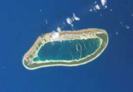
 NASA picture of Tatakoto Atoll | |
 | |
| Coordinates: 17°21′06″S 138°24′05″W / 17.3517°S 138.4013°W | |
| Country | France |
| Overseas collectivity | French Polynesia |
| Subdivision | Îles Tuamotu-Gambier |
| Area 1 | 7.3 km2 (2.8 sq mi) |
| Population (2022)[1] | 180 |
| • Density | 25/km2 (64/sq mi) |
| Time zone | UTC−10:00 |
| INSEE/Postal code | 98751 /98783 |
| 1 French Land Register data, which excludes lakes, ponds, glaciers > 1 km2 (0.386 sq mi or 247 acres) and river estuaries. | |
Tatakoto is an atoll in the Tuamotu group in French Polynesia.
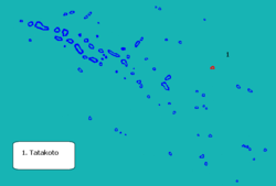
Tatakoto is one of the more isolated atolls of the Tuamotus. It is situated in the east of the archipelago, 1,182 kilometres (734 miles) from Tahiti. This atoll is 14 kilometres (9 miles) long and 3.5 kilometres (2 miles) wide. It has one large island and 65 islets separated by numerous channels on the reef surrounding the lagoon. The islands are mostly located on its windward side (south). All the islands are flat, not much higher than the ocean level. Its land area is about 7.3 km2, and the lagoon area is about 20 km2.
The main settlement is Tumukuru, and the total population was 180 in the 2022 census.[1]
- ^ a b "Les résultats du recensement de la population 2022 de Polynésie française" [Results of the 2022 population census of French Polynesia] (PDF) (in French). Institut de la statistique de la Polynésie française. January 2023.
