Tateyama
立山町 | |
|---|---|
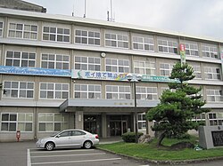
 Tateyama Town Hall | |
 Location of Tateyama in Toyama Prefecture | |
| Coordinates: 36°39′48.8″N 137°18′49.3″E / 36.663556°N 137.313694°E | |
| Country | |
| Region | Chūbu |
| Prefecture | |
| District | Nakaniikawa |
| Government | |
| • Mayor | Takayuki Funahashi |
| Area | |
| • Total | 307.29 km2 (118.65 sq mi) |
| Population (October 1, 2020) | |
| • Total | 24,862 |
| • Density | 80.90/km2 (209.5/sq mi) |
| Time zone | UTC+09:00 (JST) |
| Symbols | |
| • Tree | Cryptomeria |
| • Flower | Chrysanthemum × morifolium |
| • Flowering tree | Rhododendron indicum |
| Phone number | 076-463-1121 |
| Address | 2440 Maezawa, Tateyama-machi, Nakaniikawa-gun, Toyama-ken |
| Website | Official website |
Tateyama (立山町, Tateyama-machi) is a town located in Nakaniikawa District, Toyama Prefecture, Japan. As of 1 October 2016[update], the town had an estimated population of 26,212 in 9452 households [1] and a population density of 85 persons per km². The total area of the town was 307.29 square kilometres (118.65 sq mi).
- ^ Tateyama town official statistics(in Japanese)


