| Parque Natural Nacional Tayrona | |
|---|---|
 | |
| Location | Santa Marta, Colombia |
| Coordinates | 11°16′N 74°3′W / 11.267°N 74.050°W |
| Area | 150 km2 (58 sq mi) |
| Established | April 24, 1964 |
| Governing body | SINAP |


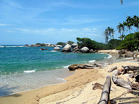
The Tayrona National Natural Park (Spanish: Parque Nacional Natural Tayrona) is a protected area in the Colombian northern Caribbean region and within the jurisdiction of the city of Santa Marta, 34 kilometres (21 mi) from the city centre. The park presents a biodiversity endemic to the area of the Sierra Nevada de Santa Marta mountain range, featuring a variety of climates (mountain climate) and geography that ranges from arid sea level to 900 meters above sea level. The park covers approximately 30 square kilometres (12 sq mi) of maritime area in the Caribbean Sea and approximately 150 square kilometres (58 sq mi) of land.
It was the second most visited national park in Colombia in 2022, with 545,760 visitors.[1]
- ^ Pinilla Pinilla, Flor Angela (January 2023). "Comportamiento de visitantes a áreas protegidas nacionales con vocación ecoturística" (PDF). parquesnacionales.gov.co. Parques Nacionales Naturales de Colombia. Retrieved 8 January 2023.

