Tazewell County | |
|---|---|
 Tazewell County Courthouse | |
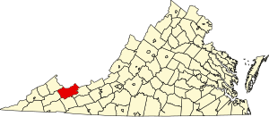
 Location within the U.S. state of Virginia | |
 Virginia's location within the U.S. | |
| Coordinates: 37°08′N 81°34′W / 37.13°N 81.56°W | |
| Country | |
| State | |
| Founded | December 20, 1799 |
| Named for | Henry Tazewell |
| Seat | Tazewell |
| Largest town | Richlands |
| Area | |
| • Total | 520 sq mi (1,300 km2) |
| • Land | 519 sq mi (1,340 km2) |
| • Water | 1.1 sq mi (3 km2) 0.2% |
| Population (2020) | |
| • Total | 40,429 |
| • Density | 78/sq mi (30/km2) |
| Time zone | UTC−5 (Eastern) |
| • Summer (DST) | UTC−4 (EDT) |
| Congressional district | 9th |
| Website | tazewellcountyva |
Tazewell County (/tæz.wɛl/) is a county located in the southwestern portion of the U.S. state of Virginia. As of the 2020 census, the population was 40,429.[1] Its county seat is Tazewell.[2]
Tazewell County is part of the Bluefield, WV-VA Micropolitan Statistical Area. Its economy was dependent on coal and iron of the Pocahontas Fields from the late 19th into the 20th century.
- ^ "Tazewell County, Virginia". United States Census Bureau. Retrieved January 30, 2022.
- ^ "Find a County". National Association of Counties. Retrieved June 7, 2011.

