Te Haumi | |
|---|---|
 | |
 | |
| Coordinates: 35°18′07″S 174°05′55″E / 35.3019°S 174.0985°E | |
| Region | Northland Region |
| District | Far North District |
| Ward | Bay of Islands-Whangaroa Ward |
| Community | Bay of Islands-Whangaroa |
| Subdivision | Paihia |
| Electorates | |
| Government | |
| • Territorial Authority | Far North District Council |
| • Regional council | Northland Regional Council |
| Area | |
| • Total | 0.62 km2 (0.24 sq mi) |
| Population (2018 Census)[2] | |
| • Total | 375 |
| • Density | 600/km2 (1,600/sq mi) |
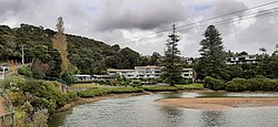
Te Haumi is a settlement south-east of Paihia and north-west of Opua in the Bay of Islands area of Northland Region, New Zealand.[3]
The Rangatira (Chief) Tohitapu lived at Te Haumi until his death in 1833.[4] He is remembered in the naming of Tohitapu Road.
- ^ Cite error: The named reference
Areawas invoked but never defined (see the help page). - ^ Cite error: The named reference
Census 2018was invoked but never defined (see the help page). - ^ Roger Smith, GeographX (2005). The Geographic Atlas of New Zealand. Robbie Burton. map 20. ISBN 1-877333-20-4.
- ^ Smith, S. Percy – Maori Wars of the Nineteenth Century (Christchurch 1910) page 458. online at NZETC