Tecopa | |
|---|---|
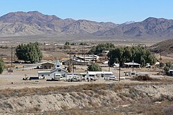
 Tecopa from the southwest | |
 Location in Inyo County and the state of California | |
| Coordinates: 35°50′54″N 116°13′35″W / 35.84833°N 116.22639°W | |
| Country | United States |
| State | California |
| County | Inyo |
| Area | |
| • Total | 18.657 sq mi (48.323 km2) |
| • Land | 18.589 sq mi (48.146 km2) |
| • Water | 0.068 sq mi (0.177 km2) 0.37% |
| Elevation | 1,545 ft (471 m) |
| Population (2020) | |
| • Total | 120[1] |
| Time zone | UTC-8 (Pacific (PST)) |
| • Summer (DST) | UTC-7 (PDT) |
| ZIP code | 92389 |
| Area codes | 442/760 |
| FIPS code | 06-78050 |
| GNIS feature ID | 2410062[3] |

Tecopa is a census-designated place (CDP) in the Mojave Desert in southeast Inyo County, California, United States. Originally occupied by the Koso and Chemehuevi Indians, Pioneers began populating what would become the CDP in the late 19th century to support nearby mines. It is now better known for the natural hot springs in the northern part of the CDP.
- ^ "Explore Census Data". data.census.gov. Retrieved October 6, 2022.
- ^ "2010 Census Gazetteer Files - Places - California". United States Census Bureau. Retrieved March 26, 2015.
- ^ a b U.S. Geological Survey Geographic Names Information System: Tecopa, California
