Tegel | |
|---|---|
 Gorkistrasse in the old town | |
| Coordinates: 52°35′00″N 13°17′00″E / 52.58333°N 13.28333°E | |
| Country | Germany |
| State | Berlin |
| City | Berlin |
| Borough | Reinickendorf |
| Founded | 1558 |
| Area | |
| • Total | 33.7 km2 (13.0 sq mi) |
| Elevation | 52 m (171 ft) |
| Population (2023-12-31)[1] | |
| • Total | 37,291 |
| • Density | 1,100/km2 (2,900/sq mi) |
| Time zone | UTC+01:00 (CET) |
| • Summer (DST) | UTC+02:00 (CEST) |
| Postal codes | 13405, 13503, 13505, 13507, 13509 |
| Vehicle registration | B |
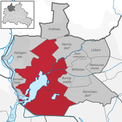
Tegel (German: [ˈteːɡl̩] ) is a locality (Ortsteil) in the Berlin borough of Reinickendorf on the shore of Lake Tegel. The Tegel locality, the second largest in area (after Köpenick) of the 96 Berlin districts, also includes the neighbourhood of Saatwinkel.


