Tekes County
| |
|---|---|
 A herdsman in Tekes County | |
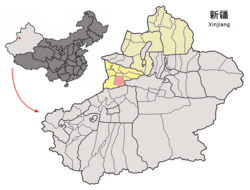
 Tekes County (red) within Ili Prefecture (yellow) and Xinjiang | |
| Coordinates: 43°12′49″N 81°50′14″E / 43.2137°N 81.8371°E | |
| Country | China |
| Autonomous region | Xinjiang |
| Autonomous prefecture | Ili |
| County seat | Tekes Town |
| Area | |
| • Total | 8,066.45 km2 (3,114.47 sq mi) |
| Population (2020)[1] | |
| • Total | 148,945 |
| • Density | 18/km2 (48/sq mi) |
| Time zone | UTC+8 (China Standard[a]) |
| Website | www |
| Tekes County | |||||||||||
|---|---|---|---|---|---|---|---|---|---|---|---|
| Chinese name | |||||||||||
| Simplified Chinese | 特克斯县 | ||||||||||
| Traditional Chinese | 特克斯縣 | ||||||||||
| |||||||||||
| Mongolian name | |||||||||||
| Mongolian Cyrillic | Такас шиан | ||||||||||
| Mongolian script | ᠲᠡᠺᠡᠰ ᠰᠢᠶᠠᠨ | ||||||||||
| Uyghur name | |||||||||||
| Uyghur | تېكەس ناھىيىسى | ||||||||||
| |||||||||||
| Kazakh name | |||||||||||
| Kazakh | تەكەس اۋدانى Текес ауданы Tekes aýdany | ||||||||||
| Kyrgyz name | |||||||||||
| Kyrgyz | تەكەس وودانى Текес ооданы Tekes oodany | ||||||||||
Tekes County is a county within the Xinjiang Uyghur Autonomous Region and is under the administration of the Ili Kazakh Autonomous Prefecture. It contains an area of 8,067 km2. According to the 2002 census, it has a population of 150,000.
The county center is known for being a planned community with a shape of a ba gua.[2]
- ^ Xinjiang: Prefectures, Cities, Districts and Counties
- ^ Sun, Yaping (孙亚萍) (2010-11-24). 新疆八卦城,丘处机定雏形 [Xinjiang Ba Gua City, the Rudiment Established by Qiu Chuji] (in Simplified Chinese). 国际在线. Retrieved 16 October 2012. Archived: Internet Archive link of 01.08.2020
Cite error: There are <ref group=lower-alpha> tags or {{efn}} templates on this page, but the references will not show without a {{reflist|group=lower-alpha}} template or {{notelist}} template (see the help page).


