תֵּל יָקְנְעָם | |
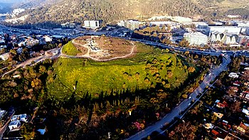
 Tel Yokneam seen from Mount Carmel, with modern Yokneam Illit to the right and the town of Yokneam Moshava to the left | |
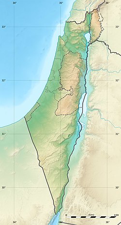
| Location | Israel |
|---|---|
| Region | Jezreel Valley, Israel |
| Coordinates | 32°39′51″N 35°06′6.3″E / 32.66417°N 35.101750°E |
| Type | Tell |
| Area | 10 acres/4 ha/40 dunams (20 acres with slopes) |
| Height | 60 meters (200 ft) |
| History | |
| Founded | Rock-cut tombs c. 2000 BCE, fortified city c. 1900 BCE |
| Abandoned | Ottoman period |
| Periods | Chalcolithic, Bronze Age, Iron Age, Persian, Hellenistic, Roman, Byzantine, Early Islamic, Crusader, Mamluk, Ottoman |
| Site notes | |
| Archaeologists |
|
Tel Yokneam, also spelled Yoqne'am or Jokneam (Hebrew: תֵּל יָקְנְעָם), is an archaeological site located in the northern part of the modern city of Yokneam Illit, Israel. It is known in Arabic as Tell Qamun (Arabic: تل قامون), believed to be a corruption of the Hebrew name.[1] The site is an elevated mound, or tell, spanning around 40 dunams (10 acres/4 ha) and rising steeply to a height of 60 meters (200 ft).[2] With a few brief interruptions, Yokneam was occupied for 4,000 years, from the Middle Bronze Age to the Ottoman period.[3]
The ancient settlement at Tel Yokneam is first mentioned in Egyptian sources as a city conquered by Pharaoh Thutmose III.[4] It appears later in the Hebrew Bible as a city defeated by Israelite leader Joshua and settled by the Tribe of Levi.[5] It is mentioned twice in Roman sources.[6] During the Crusades, it was called Caymont, or Cain Mons, recalling a legend that Yokneam was the site of Cain's death.[7] For a period, it was the center of the Lordship of Caymont, the smallest seigneurie of the Crusader kingdom of Jerusalem.[8]
The earliest archaeological features of Yokneam date from the Chalcolithic period, in the fourth millennium BCE. The first structures date from the beginning of the second millennium BCE.[9] During the Middle and Late Bronze Ages (2000–1200 BCE), Yokneam was for the most part a fortified city,[10] which was razed during a period known as the Late Bronze Age collapse.[11] During the Iron Age, the city was razed and rebuilt several times; events which are attributed to the biblical accounts of the conquests by Joshua, King David, Hazael of Aram-Damascus, and the Neo-Assyrian Empire.[5][12][13][14] The period between the 10th and 8th centuries BCE is considered Yokneam's golden age, during which it extended beyond the mound's limits.[15] The city was protected at that time by a massive fortification system.[14] During Persian rule (539–330 BC) Yokneam was a dense, unfortified, and cosmopolitan city, housing Jews, Phoenicians, and Persians.[16][17] Very little has been found in Yokneam from the Hellenistic, Roman, and Byzantine periods (333 BCE–634 CE), because the settlement was probably located on a different hill, south of Tel Yokneam.[18] The remains of a Byzantine church were found in the southern part of the mound.[19] After the Islamic conquest of 634 AD, a well-planned city was established on the mound by the Abbasid Caliphate. It was gradually abandoned and was struck by an earthquake in 1033 CE.[20] In the 12th century CE, the Crusaders built a fortified city on the site, the largest since the Iron Age.[21] The city eventually fell to the Muslims, and was rebuilt by the Mamluks during the 14th century CE.[22] After the Ottoman conquest of 1517 CE, a fortress was built in the 18th century, and later abandoned in the 19th century.[23]
The site, which had remained abandoned, was surveyed by the Palestine Exploration Fund in 1878,[24] and by Avner Raban in the 1970s.[15] It was first excavated as part of a "Yoqne'am Regional Project" run by the Hebrew University of Jerusalem and the Israel Exploration Society. The excavations, between 1977 and 1988, were directed by the archaeologist Amnon Ben-Tor.[2] Some of the digs were also headed by Renate Rosenthal and Yuval Portugali.[25] Two other sites were studied in that project: Tel Qashish and Tel Qiri.[2] Further excavations were conducted on the acropolis by Miriam Avissar in 1993.[23]
Today. there is an archaeological park and a visitor center on the mound. The park is operated by the Israel Antiquities Authority and the municipality of Yokneam Illit. It was created as part of a conservation project, with the participation of school students from Yokneam Illit.[26]
- ^ Cite error: The named reference
Robinsonwas invoked but never defined (see the help page). - ^ a b c Yoqne'am I, pp. 1–2
- ^ Ben-Tor, 1987, p. 2
- ^ Yuval Goren, Israel Finkelstein, and Nadav Na'aman. "Petrographic Investigation of the Amarna Tablets." Near Eastern Archaeology 65, no. 3 (2002): 202–203.
- ^ a b Elizabeth Bloch-Smith and Beth Alpert Nakhai, "A Landscape Comes to Life: The Iron Age I", Near Eastern Archaeology, Vol. 62, No. 2, The University of Chicago Press on behalf of The American Schools of Oriental Research, p. 83–85
- ^ Amnon Ben-Tor and Renate Rosenthal, Ben-Tor, Amnon; Rosenthal, Renate (1978). "The First Season of Excavations at Tel Yoqne'am, 1977: Preliminary Report". Israel Exploration Journal. 28 (1\2). Israel Exploration Society: 62 and 65. JSTOR 27925647.
- ^ Cite error: The named reference
Tentwas invoked but never defined (see the help page). - ^ Cite error: The named reference
kedar4was invoked but never defined (see the help page). - ^ Sharon Zuckerman, "Chapter Eighth – The Early Bronze Age Remains" in Yoqne'am III pp. 351–360
- ^ Cite error: The named reference
qedem1was invoked but never defined (see the help page). - ^ Yoqne'am Regional Project – 1984–1987, p.19
- ^ Cite error: The named reference
87BT7was invoked but never defined (see the help page). - ^ Ghantous, Hadi (2014). The Elisha-Hazael Paradigm and the Kingdom of Israel: The Politics of God in Ancient Syria-Palestine. Routledge. p. 32. ISBN 978-1-84465-739-1.
- ^ a b Cite error: The named reference
87BT8was invoked but never defined (see the help page). - ^ a b Feig, Nurit (6 December 2016). "Yoqneʽam". Hadashot Arkheologiyot. 128. Israel Antiquities Authority. Archived from the original on 19 January 2019. Retrieved 26 September 2019.
- ^ Cimadevilla (2005), pp. 409–410
- ^ Prof. Rappoport, Uriel; Dr. Yaron, Shlomit (2004). From Cyrus to Alexander: The Jews Under Persian Rule (in Hebrew). Open University of Israel. p. 188. ISBN 978-965-06-0764-7.
- ^ Cite error: The named reference
96p13was invoked but never defined (see the help page). - ^ Cite error: The named reference
Boaswas invoked but never defined (see the help page). - ^ Yoqne'am I, pp. 17–20, 217
- ^ Portugali, Yoqne'am I, 1996
- ^ Yoqne'am I, p. 172
- ^ a b Miriam Avissar, אבישר, מרים (1995). "Tel Yoqne'am, The Crusader Acropolis". Hadashot Arkheologiyot (in Hebrew). קג. Israel Antiquities Authority: 36–37. JSTOR 23473763. − via JSTOR
- ^ "Conder and Kitchener, 1882, SWPII, pp. 69–70". Archived from the original on 2016-10-28. Retrieved 2019-02-09.
- ^ Amnon Ben-Tor and Anabel Zarzecki-Peleg, "Yoqne'am Regional Project – 1984–1987", Hadashot Arkheologiyot. Israel Antiquities Authority (1987) (in Hebrew). pp. 18–24
- ^ Vaknin, Yossi (29 April 2019). "New Archaeological Visitor Center Opened in Yokneam". Ynet (in Hebrew). No. Mynet. Jezreel Valley.

