Temoaya | |
|---|---|
Municipality | |
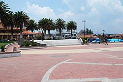
 Main plaza of Temoaya | |
| Coordinates: 19°28′07″N 99°35′36″W / 19.46861°N 99.59333°W | |
| Country | |
| State | State of Mexico |
| Municipal Seat | Temoaya |
| Town Founded | 1220 |
| Municipality Founded | 1820 |
| Government | |
| • Municipal President | C. Enrique Valdes Garcia |
| Elevation (of seat) | 2,670 m (8,760 ft) |
| Population (2005) Municipality | |
| • Municipality | 77,714 |
| • Seat | 2,987 |
| Time zone | UTC-6 (Central (US Central)) |
| • Summer (DST) | UTC-5 (Central) |
| Postal code (of seat) | 50850 |
| Website | http://www.temoaya.gob.mx/ |
Temoaya is a municipality in the State of Mexico, Mexico.[1] It's municipal seat is the town of Temoaya which is the sixth largest town in the municipality. It is located 18 kilometres (11 mi) from Toluca and 85 kilometres (53 mi) from Mexico City. It is known for its large ethnic Otomi population, the Centro Ceremonial Otomí and its tradition of making Persian style rugs using Mexican designs.[2][3]
The name “Temoaya” comes from the Nahuatl phrase “Temoayan” which means “place of descending.” The Aztec glyph which depicts the municipality shows footprints descending a mountain.[2] In local Otomi, the town is called "Nthekunthe" (meeting place between brothers), however more originally the settlement was named "Ndongu" ("house of the rock" or "casa grande", a large public structure)
- ^ INEGI. "Mapa digital de México" (in Spanish). Instituto Nacional de Estadística, Geografía e Informática. Retrieved 2008-01-28.
- ^ a b "Temoaya". Enciclopedia de los Municipios de Mexico – Estado de México (in Spanish). Mexico: Instituto Nacional para el Federalismo y el Desarrollo Municipal. 2005. Archived from the original on May 28, 2007. Retrieved June 22, 2010.
- ^ "Anudado de Tapetes Temoaya" [Knotted rugs of Temoaya] (in Spanish). Temoaya, Mexico: Revista Temoaya. May 2009. Archived from the original on July 3, 2010. Retrieved June 22, 2010.