Tenino, Washington | |
|---|---|
 Downtown Tenino, along Sussex Ave., 2011 | |
| Nickname: The Stone City[1] | |
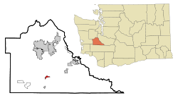
 Location of Tenino, Washington | |
| Coordinates: 46°51′24″N 122°51′1″W / 46.85667°N 122.85028°W | |
| Country | United States |
| State | Washington |
| County | Thurston |
| Area | |
| • Total | 1.46 sq mi (3.77 km2) |
| • Land | 1.46 sq mi (3.77 km2) |
| • Water | 0.00 sq mi (0.00 km2) |
| Elevation | 289 ft (88 m) |
| Population | |
| • Total | 1,870 |
| • Estimate (2021)[4] | 1,958 |
| • Density | 1,280.91/sq mi (494.66/km2) |
| Time zone | UTC-8 (PST) |
| • Summer (DST) | UTC-7 (PDT) |
| ZIP code | 98589 |
| Area code | 360 |
| FIPS code | 53-70630 |
| GNIS feature ID | 1512718[5] |
| Website | cityoftenino.us |
Tenino (/təˈnaɪnoʊ/) is a city in Thurston County, Washington, United States. The population was 1,870 at the 2020 census.[3]
Incorporated in 1906, the city sits upon land first established as a food-source prairie for Native Americans living in the area. The town grew around an economy of stone quarrying, with local sandstone being used in several government and university buildings in the Pacific Northwest. With a decrease in demand for stone, the town converted one abandoned quarry into a community pool. Its downtown district is listed on the National Register of Historic Places.[6]
Tenino gained notoriety during the Great Depression for the use of wooden money as public currency for its residents, a practice briefly revived during the COVID-19 pandemic.[7][8] The city was named for a steamboat used during a railroad committee expedition.[9]
- ^ Rails-to-Trails Conservancy (2015). Rail-Trails Washington & Oregon (1st ed.). Wilderness Press. p. 116. ISBN 9780899977942.
- ^ "2019 U.S. Gazetteer Files". United States Census Bureau. Retrieved August 7, 2020.
- ^ a b "Explore Census Data". United States Census Bureau. Retrieved May 15, 2022.
- ^ Cite error: The named reference
USCensusEst2021was invoked but never defined (see the help page). - ^ "US Board on Geographic Names". United States Geological Survey. October 25, 2007. Retrieved January 31, 2008.
- ^ "National Register Information System". National Register of Historic Places. National Park Service. March 13, 2009.
- ^ Cite error: The named reference
TWMwas invoked but never defined (see the help page). - ^ Cite error: The named reference
AWCTwas invoked but never defined (see the help page). - ^ Cite error: The named reference
:0was invoked but never defined (see the help page).