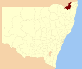
| Tenterfield Shire New South Wales | |||||||||||||||
|---|---|---|---|---|---|---|---|---|---|---|---|---|---|---|---|
 Location in New South Wales | |||||||||||||||
| Coordinates | 29°03′09″S 152°01′07″E / 29.05250°S 152.01861°E | ||||||||||||||
| Population |
| ||||||||||||||
| • Density | 0.90398/km2 (2.3413/sq mi) | ||||||||||||||
| Area | 7,332 km2 (2,830.9 sq mi) | ||||||||||||||
| Mayor | Peter Petty (Unaligned) | ||||||||||||||
| Council seat | Tenterfield[3] | ||||||||||||||
| Region | New England | ||||||||||||||
| State electorate(s) | Lismore | ||||||||||||||
| Federal division(s) | New England | ||||||||||||||
 | |||||||||||||||
| Website | Tenterfield Shire | ||||||||||||||
| |||||||||||||||
Tenterfield Shire is a local government area located in the New England region of New South Wales, Australia. The Shire is situated adjacent to the New England Highway.
The mayor of the Tenterfield Shire Council is Cr. Bronwyn Petrie, an unaligned politician.
- ^ Australian Bureau of Statistics (27 June 2017). "Tenterfield (A)". 2016 Census QuickStats. Retrieved 8 December 2017.
- ^ "3218.0 – Regional Population Growth, Australia, 2017-18". Australian Bureau of Statistics. 27 March 2019. Retrieved 27 March 2019. Estimated resident population (ERP) at 30 June 2018.
- ^ "Tenterfield Shire Council". Department of Local Government. Retrieved 2 December 2006.