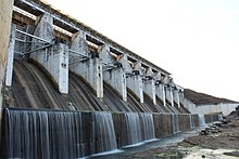
| Tenughat Dam | |
|---|---|
 | |
| Official name | Tenughat Dam |
| Country | India |
| Location | Bokaro District, Jharkhand |
| Coordinates | 23°43′48″N 85°49′55″E / 23.73000°N 85.83194°E |
| Status | Functional |
| Construction began | 1973 |
| Opening date | 1978 (year of completion) |
| Owner(s) | Government of Jharkhand |
| Dam and spillways | |
| Type of dam | Earthfill embankment |
| Impounds | Damodar River |
| Height | 55 metres (180 ft) |
| Height (foundation) | 50.61 meters |
| Length | 6,494 metres (21,306 ft) |
| Spillways | 60 Feet clear Width |
| Spillway capacity | 15989 cubic meters/s |
| Reservoir | |
| Creates | Khandoli Lake |
| Total capacity | 1.021 cubic kms (36.06 tmcft) |
| Active capacity | 1.00 cubic km (35.32 tmcft) |
Tenughat Dam (Hindi: तेनूघाट बांध) is an earthfill dam with composite masonry cum concrete spillway across the Damodar River at Tenughat in Petarwar block of Bokaro district in the Indian state of Jharkhand.
