| Teton Range | |
|---|---|
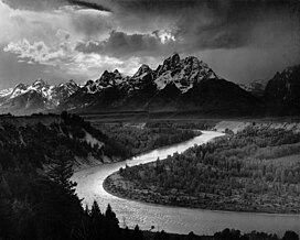
 Teton Range, from the Snake River overlook, by Ansel Adams | |
| Highest point | |
| Peak | Grand Teton |
| Elevation | 13,775 ft (4,199 m) NAVD 88[1] |
| Coordinates | 43°44′28″N 110°48′06″W / 43.74111°N 110.80167°W |
| Dimensions | |
| Length | 40 mi (64 km) |
| Width | 12 mi (19 km) |
| Geography | |
 | |
| Country | United States |
| State | Wyoming |
| Range coordinates | 43°45′N 110°50′W / 43.750°N 110.833°W |
| Parent range | Rocky Mountains |

The Teton Range is a mountain range of the Rocky Mountains in North America. It extends for approximately 40 miles (64 km) in a north–south direction through the U.S. state of Wyoming, east of the Idaho state line. It is south of Yellowstone National Park, and most of the east side of the range is within Grand Teton National Park.
One theory says the early French voyageurs named the range les trois tétons ("the three nipples") after the breast-like shapes of its peaks.[2] Another theory says the range is named for the Teton Sioux (from Thítȟuŋwaŋ), also known as the Lakota people.[3] It is likely that the local Shoshone people once called the whole range Teewinot, meaning "many pinnacles".[4]
The principal summits of the central massif, sometimes referred to as the Cathedral Group, are Grand Teton (13,775 feet (4,199 m)), Mount Owen (12,928 feet (3,940 m)), Teewinot (12,325 feet (3,757 m)), Middle Teton (12,804 feet (3,903 m)) and South Teton (12,514 feet (3,814 m)). Other peaks in the range include Mount Moran (12,605 feet (3,842 m)), Mount Wister (11,490 feet (3,500 m)), Buck Mountain (11,938 feet (3,639 m)) and Static Peak (11,303 feet (3,445 m)).
- ^ "Grand Teton". NGS Data Sheet. National Geodetic Survey, National Oceanic and Atmospheric Administration, United States Department of Commerce. Retrieved September 12, 2009.
- ^ "Creation of the Teton Landscape: The Geologic Story of Grand Teton National Park - The Story Begins". National Park Service. January 19, 2007. Retrieved November 2, 2024.
- ^ Ullrich, Jan. (2008). New Lakota Dictionary. Lakota Language Consortium. ISBN 0-9761082-9-1
- ^ "Teton range peak names". DeAnza College. September 22, 2013. Archived from the original on April 9, 2016. Retrieved October 17, 2013.