This article needs additional citations for verification. (May 2015) |
Texel | |
|---|---|
Municipality and island | |
 North end of the island with the Eierland Lighthouse in 2015 | |
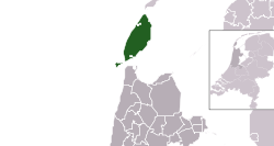
 Location in North Holland | |
| Coordinates: 53°3′N 4°48′E / 53.050°N 4.800°E | |
| Country | Netherlands |
| Province | North Holland |
| Government | |
| • Body | Municipal council |
| • Mayor | Mark Pol (VVD) |
| Area | |
| • Total | 463.16 km2 (178.83 sq mi) |
| • Land | 162.00 km2 (62.55 sq mi) |
| • Water | 301.16 km2 (116.28 sq mi) |
| Elevation | 2 m (7 ft) |
| Population (January 2021)[4] | |
| • Total | 13,656 |
| • Density | 84/km2 (220/sq mi) |
| Demonym(s) | Tesselaar, Texelaar |
| Time zone | UTC+1 (CET) |
| • Summer (DST) | UTC+2 (CEST) |
| Postcode | 1790–1797 |
| Area code | 0222 |
| Website | www |
Texel (Dutch pronunciation: [ˈtɛsəl] ; Texels dialect: Tessel) is a municipality and an island with a population of 13,643 in North Holland, Netherlands. It is the largest and most populated island of the West Frisian Islands in the Wadden Sea. The island is situated north of Den Helder, northeast of Noorderhaaks, and southwest of Vlieland.
- ^ "B&W samenstelling en portefeuilles" [Mayor and aldermen members and tasks] (in Dutch). Gemeente Texel. Archived from the original on 27 July 2014. Retrieved 22 March 2014.
- ^ "Kerncijfers wijken en buurten 2020" [Key figures for neighbourhoods 2020]. StatLine (in Dutch). CBS. 24 July 2020. Retrieved 19 September 2020.
- ^ "Postcodetool for 1791AT". Actueel Hoogtebestand Nederland (in Dutch). Het Waterschapshuis. Retrieved 22 March 2014.
- ^ "Bevolkingsontwikkeling; regio per maand" [Population growth; regions per month]. CBS Statline (in Dutch). CBS. 1 January 2021. Retrieved 2 January 2022.

