Thames-Coromandel District | |
|---|---|
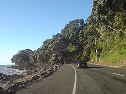
 The road northwards from Thames. Somewhere south of Te Mata. | |
 Thames-Coromandel district within the North Island | |
| Coordinates: 36°56′31″S 175°40′34″E / 36.942°S 175.676°E | |
| Country | New Zealand |
| Region | Waikato |
| Wards | Coromandel-Colville Mercury Bay South East Thames |
| Formed | 1975 |
| Seat | Thames |
| Government | |
| • Mayor | Len Salt |
| • Territorial authority | Thames-Coromandel District Council |
| Area | |
| • Land | 2,207.59 km2 (852.36 sq mi) |
| Population (June 2024)[2] | |
• Total | 33,300 |
| Time zone | UTC+12 (NZST) |
| • Summer (DST) | UTC+13 (NZDT) |
| Postcode(s) | |
| Website | Thames-Coromandel District Council |
The Thames-Coromandel District is a territorial authority district in the North Island of New Zealand, covering all the Coromandel Peninsula and extending south to Hikutaia.
It is administered by the Thames-Coromandel District Council, which has its seat in the town of Thames. It was the first district council to be formed in New Zealand, being constituted in 1975. The district lies within the Waikato Regional Council area. Its only land boundary is with Hauraki District.
- ^ Cite error: The named reference
Areawas invoked but never defined (see the help page). - ^ "Aotearoa Data Explorer". Statistics New Zealand. Retrieved 26 October 2024.