Tharandt | |
|---|---|
 | |
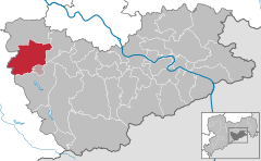
Location of Tharandt within Sächsische Schweiz-Osterzgebirge district  | |
| Coordinates: 50°59′0″N 13°34′51″E / 50.98333°N 13.58083°E | |
| Country | Germany |
| State | Saxony |
| District | Sächsische Schweiz-Osterzgebirge |
| Municipal assoc. | Tharandt |
| Subdivisions | 7 |
| Government | |
| • Mayor (2020–27) | Silvio Ziesemer[1] |
| Area | |
| • Total | 71.22 km2 (27.50 sq mi) |
| Elevation | 214 m (702 ft) |
| Population (2022-12-31)[2] | |
| • Total | 5,471 |
| • Density | 77/km2 (200/sq mi) |
| Time zone | UTC+01:00 (CET) |
| • Summer (DST) | UTC+02:00 (CEST) |
| Postal codes | 01737 |
| Dialling codes | 035203 |
| Vehicle registration | PIR |
| Website | www.tharandt.de |
Tharandt (German: [ˈtaʁant] ) is a municipality in Saxony, Germany, situated on the Weißeritz, 13 km (8.1 mi) southwest of Dresden.
It has a Protestant Church and the oldest academy of forestry in Germany, founded as the Royal Saxon Academy of Forestry by Heinrich Cotta in 1811,[3] together with its arboretum, the Forstbotanischer Garten Tharandt. In 2002, a severe flood destroyed many of the academy buildings and the library, including some of its more-than-500-year old books. The academy was rebuilt and today has about 650 students and is famous for its long traditions of educating students from all over the world in (tropical) forestry, resource management and sustainable land use.
In the early 20th century, Tharandt was a favorite summer resort of the people of Dresden, one of its principal charms being the magnificent beech woods which surround it.[3]
- ^ Wahlergebnisse 2020, Freistaat Sachsen, accessed 10 July 2021.
- ^ "Einwohnerzahlen nach Gemeinden als Excel-Arbeitsmappe" (XLS) (in German). Statistisches Landesamt des Freistaates Sachsen. 2024.
- ^ a b One or more of the preceding sentences incorporates text from a publication now in the public domain: Chisholm, Hugh, ed. (1911). "Tharandt". Encyclopædia Britannica. Vol. 26 (11th ed.). Cambridge University Press. p. 726.


