| The Black Tusk | |
|---|---|
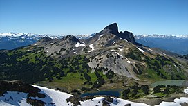
 The Black Tusk viewed from the southeast | |
| Highest point | |
| Elevation | 2,319 m (7,608 ft)[1] |
| Prominence | 569 m (1,867 ft)[1] |
| Listing | Mountains of British Columbia |
| Coordinates | 49°58′31″N 123°02′34″W / 49.97528°N 123.04278°W[2] |
| Geography | |
| Country | Canada |
| Province | British Columbia |
| District | New Westminster Land District |
| Protected area | Garibaldi Provincial Park |
| Parent range | Garibaldi Ranges |
| Topo map | NTS 92G14 Cheakamus River |
| Geology | |
| Rock age | Pleistocene |
| Mountain type | Stratovolcano |
| Volcanic arc/belt | Canadian Cascade ArcGaribaldi Volcanic Belt |
| Last eruption | Pleistocene |
| Climbing | |
| First ascent | 1912 by William J. Gray and party[1] |
| Easiest route | Exposed rock scramble |
The Black Tusk, known as Q̓elqámtensa ti Skenknápa in the St'at'imcets (Lillooet) language and as T'ákt'akmúten tl'a Ín7inyáx̱a7en in the Sḵwx̱wú7mesh (Squamish) language, is a stratovolcano and a pinnacle of volcanic rock in Garibaldi Provincial Park of British Columbia, Canada. At 2,319 m (7,608 ft) above sea level,[3] the upper spire is visible from a great distance in all directions. It is particularly noticeable from the Sea-to-Sky Highway just south of Whistler, British Columbia. Distinctive and immediately identifiable, The Black Tusk is among the best known mountains in the Garibaldi Ranges of the Coast Mountains. The volcano is part of the Garibaldi Volcanic Belt which is a segment of the Canadian Cascade Arc, but it is not within the geographic boundary of the Cascade Range.
- ^ a b c "The Black Tusk". Bivouac.com. Retrieved 2005-12-26.
- ^ "The Black Tusk". BC Geographical Names. Retrieved 2005-12-26.
- ^ Cite error: The named reference
Gunnwas invoked but never defined (see the help page).
