The Bottle | |
|---|---|
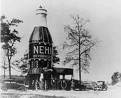
 A 1924 picture of "The Bottle" | |
| Coordinates: 32°40′34″N 85°29′11″W / 32.67611°N 85.48639°W | |
| Country | United States |
| State | Alabama |
| County | Lee |
| Elevation | 761 ft (232 m) |
| Time zone | UTC-6 (CST) |
| • Summer (DST) | UTC-6 (EDT) |
| GNIS feature ID | 153675[1] |
The Bottle is a community located in the northern corporate limits of Auburn, Alabama, United States. The Bottle is located at the intersection of U.S. Highway 280 and Alabama Highway 147, five miles (8.0 km) north of downtown Auburn, and adjacent to the Auburn University North Fisheries Research Complex.
The Bottle is located at 32°40′34″N 85°29′11″W; its elevation is 760 feet (230 m).
The Bottle is named for the bright orange wooden replica of a Nehi soda bottle which stood in the location from 1924 to 1936. It has frequently been noted on lists of unusual place names.[2]
- ^ U.S. Geological Survey Geographic Names Information System: The Bottle, Alabama
- ^ Duncan, Andy (2005). Alabama Curiosities: Quirky Characters, Roadside Oddities & Other Offbeat Stuff. Globe Pequot. pp. xii. ISBN 9780762730889.[permanent dead link]

