| The Cheviot | |
|---|---|
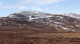
 The Cheviot in snow | |
| Highest point | |
| Elevation | 815 m (2,674 ft)[1][2] |
| Prominence | 556 m (1,824 ft)[2] |
| Parent peak | Broad Law |
| Listing | Marilyn, Hewitt, County Top, Nuttall |
| Coordinates | 55°28′42″N 2°08′44″W / 55.47823°N 2.14553°W |
| Naming | |
| English translation | (Hill) having the quality of a ridge |
| Language of name | Common Brittonic[3] |
| Geography | |
The Cheviot in Northumberland | |
| Location | Cheviot Hills, England |
| OS grid | NT909205 |
| Topo map | OS Landranger 74/75 |
| Geology | |
| Rock age | Early Devonian[4] |
| Mountain type | Stratovolcano (extinct) with pluton |
| Last eruption | +393 MYA[4] |
The Cheviot (/ˈtʃiːviət/) is an extinct volcano and the highest summit in the Cheviot Hills and in the county of Northumberland.[1][5] Located in the extreme north of England, it is a 1+1⁄4-mile (2-kilometre) walk from the Scottish border and, with a height of 2,674 feet (815 metres) above sea-level, is located on the northernmost few miles of the Pennine Way,[6] before the descent into Kirk Yetholm.
The Cheviot was formed when melting in the crust over 390 million years ago gave rise to volcanic activity, producing a stratovolcano and pluton, and it has subsequently sustained intense erosion.[7] Several watercourses radiate from The Cheviot.[8]
- ^ a b Bathurst, David (2012). Walking the county high points of England. Chichester: Summersdale. pp. 264–271. ISBN 978-1-84-953239-6.
- ^ a b "The Cheviot".
- ^ Cite error: The named reference
blitonwas invoked but never defined (see the help page). - ^ a b Scrutton, Colin. "Page 1 Cheviot - early Devonian volcanic rocks, granite and basement". Archived from the original on 11 June 2021.
- ^ Hall, Gemma (2012). Slow Northumberland and Durham. Slow Northumberland and Durham - Including Newcastle, Hadrian's Wall and the Coast: Bradt Travel Guides. ISBN 9781841624334.
- ^ Cite error: The named reference
NTBNPwas invoked but never defined (see the help page). - ^ Cite error: The named reference
GHNwas invoked but never defined (see the help page). - ^ [1] How this tranquil part of the North East is far from the madding crowd . Chronicle Live. Retrieved November 28, 2021.
