This article may rely excessively on sources too closely associated with the subject, potentially preventing the article from being verifiable and neutral. (February 2013) |
The Kingsway | |
|---|---|
Neighbourhood | |
 Entrance to the Kingsway on Bloor Street West | |
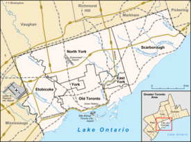
 Vicinity of The Kingsway | |
| Coordinates: 43°38′51″N 79°30′41″W / 43.64750°N 79.51139°W | |
| Country | Canada |
| Province | Ontario |
| City | Toronto |
| Established | 1850 Etobicoke Township |
| Subdivided | 1912 (Subdivision) |
| Changed municipality | 1998 Toronto from City of Etobicoke |
| Government | |
| • MP | James Maloney (Etobicoke—Lakeshore) |
| • MPP | Christine Hogarth (Etobicoke—Lakeshore) |
| • Councillor | Mark Grimes (Ward 5 Etobicoke—Lakeshore) |
The Kingsway is a residential neighbourhood in Toronto, Ontario, Canada. It is bounded by Bloor Street to the south, Dundas Street to the north, the Mimico Creek to the west and the Humber River to the east. The neighbourhood was officially known as Kingsway Park, which later became replaced by its nickname the Kingsway. In this neighbourhood, the Kingsway specifically refers to a two-lane road beginning in the south-east corner of the neighbourhood extending northerly in a north-west direction past Dundas Street.
For planning purposes, the neighbourhood is known by the City of Toronto as "Kingsway South" to differentiate it from a more recent extension of the Kingsway road north of Dundas Street. "Kingsway South" is not used by residents, due to confusion with the South Kingsway, a street located east of the Humber River and extending south from Bloor Street. Originally the Kingsway road and South Kingsway were supposed to be one continuous route, however the intended connection (including a crossing of the Humber River) was instead occupied by the westward extension of Bloor Street. South Kingsway consequently acts as a southern continuation of Jane Street.
