This article needs additional citations for verification. (November 2008) |
The Maritimes
Les Maritimes (French) | |
|---|---|
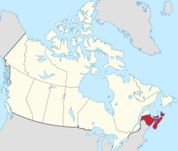
 The Maritime provinces (red) within the rest of Canada | |
| Composition | |
| Largest metro | Halifax |
| Area | |
| • Total | 130,017.11 km2 (50,199.89 sq mi) |
| Population (2021) | |
| • Total | 1,899,324 |
| • Density | 15/km2 (38/sq mi) |
| Demonym | Maritimer |
| Time zone | UTC−4:00 (AST) |
| • Summer (DST) | UTC−3:00 (ADT) |
The Maritimes, also called the Maritime provinces, is a region of Eastern Canada consisting of three provinces: New Brunswick, Nova Scotia, and Prince Edward Island. The Maritimes had a population of 1,899,324 in 2021, which makes up 5.1% of Canada's population.[1] Together with Canada's easternmost province, Newfoundland and Labrador, the Maritime provinces make up the region of Atlantic Canada.[2]
Located along the Atlantic coast, various aquatic sub-basins are located in the Maritimes, such as the Gulf of Maine and Gulf of St. Lawrence. The region is located northeast of New England in the United States, south and southeast of Quebec's Gaspé Peninsula, and southwest of the island of Newfoundland. The notion of a Maritime Union has been proposed at various times in Canada's history; the first discussions in 1864 at the Charlottetown Conference contributed to Canadian Confederation. This movement formed the larger Dominion of Canada. The Mi'kmaq, Maliseet and Passamaquoddy people are indigenous to the Maritimes, while Acadian and British settlements date to the 17th century.
- ^ "Population and dwelling counts: Canada, provinces and territories, 2021 Census". February 9, 2022.
- ^ "Introduction - Atlantic Canada". February 12, 2010.