| The Palisades | |
|---|---|
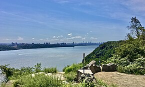
 The cliffs of the Palisades as seen from the Ross Dock Picnic Area in Palisades Interstate Park | |
 | |
| Location | Northeastern New Jersey (Hudson and Bergen counties) Downstate New York (Rockland County) |
| Coordinates | 40°57′52″N 73°54′31″W / 40.96451°N 73.90859°W |
| Designated | 1983 |

The Palisades, also called the New Jersey Palisades or the Hudson River Palisades, are a line of steep cliffs along the west side of the lower Hudson River in Northeastern New Jersey and Southeastern New York in the United States. The cliffs stretch north from Jersey City about 20 miles (32 km) to near Nyack, New York, and are visible at Haverstraw, New York. They rise nearly vertically from near the edge of the river, and are about 300 feet (90 m) high at Weehawken, increasing gradually to 540 feet (160 m) high near their northern terminus.[1] North of Fort Lee, the Palisades are part of Palisades Interstate Park and are a National Natural Landmark.[2]
The Palisades are among the most dramatic geologic features in the vicinity of New York City, forming a canyon of the Hudson north of the George Washington Bridge, as well as providing a vista of the Manhattan skyline. They sit in the Newark Basin, a rift basin located mostly in New Jersey.
Palisade is derived from the same root as the word pole, ultimately from the Latin word palus, meaning stake. A "palisade" is, in general, a defensive fence or wall made up of wooden stakes or tree trunks. The Lenape called the cliffs "rocks that look like rows of trees", a phrase that became "Weehawken", the name of a town in New Jersey that sits at the top of the cliffs across from Midtown Manhattan.
- ^ "Township of Palisade" on the Bergen County website
- ^ "National Natural Landmarks - National Natural Landmarks (U.S. National Park Service)". www.nps.gov. Retrieved April 15, 2019.
Year designated: 1983