| The Steeples | |
|---|---|
 The Steeples | |
| Highest point | |
| Elevation | 2,804 m (9,199 ft)[1] |
| Prominence | 609 m (1,998 ft)[1] |
| Parent peak | Mount Fisher (2843 m)[1] |
| Listing | Mountains of British Columbia |
| Coordinates | 49°33′54″N 115°25′20″W / 49.56500°N 115.42222°W[2] |
| Geography | |
| Location | British Columbia, Canada |
| District | Kootenay Land District |
| Parent range | Hughes Range Canadian Rockies |
| Topo map | NTS 82G11 Fernie[2] |
| Climbing | |
| Easiest route | Scrambling |
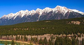
The Steeples is a 2,843-metre (9,327-foot) elevation mountain ridge located at the southern end of the Hughes Range in the Canadian Rockies of British Columbia, Canada. Situated immediately east of Norbury Lake Provincial Park and the Rocky Mountain Trench, this prominent five kilometres in length ridge is visible from the Crowsnest Highway and Cranbrook. The nearest higher peak is Mount Fisher, 10.0 km (6.2 mi) to the north-northwest.[1]
- ^ a b c d "The Steeples". Bivouac.com. Retrieved 2019-02-22.
- ^ a b "The Steeples". Geographical Names Data Base. Natural Resources Canada. Retrieved 2019-02-22.

