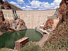
| Theodore Roosevelt Dam | |
|---|---|
 Roosevelt Dam in 2015 | |
| Country | United States |
| Location | Gila County / Maricopa County, Arizona |
| Coordinates | 33°40′18″N 111°09′40″W / 33.67167°N 111.16111°W |
| Status | Operational |
| Construction began | 1903[1] |
| Opening date | 1911 |
| Owner(s) | Bureau of Reclamation |
| Operator(s) | Salt River Project |
| Dam and spillways | |
| Type of dam | Arch-gravity dam |
| Impounds | Salt River, Tonto Creek |
| Height | 357 ft (109 m) |
| Length | 1,210 ft (369 m) |
| Width (crest) | 21.6 ft (6.6 m) |
| Width (base) | 196 ft (60 m) |
| Dam volume | 606,000 cu yd (463,000 m3) |
| Spillway capacity | 150,000 cu ft/s (4,200 m3/s) |
| Reservoir | |
| Creates | Theodore Roosevelt Lake |
| Total capacity | 1,653,043 acre⋅ft (2.039×10⁹ m3) (conservation)[2] 2,910,200 acre⋅ft (3.590×10⁹ m3) (flood control)[3] |
| Catchment area | 5,830 sq mi (15,100 km2) |
| Surface area | 21,493 acres (86.98 km2) (conservation) |
| Power Station | |
| Operator(s) | Salt River Project |
| Hydraulic head | 249 ft (76 m) |
| Installed capacity | 36 MW (48,000 hp)[2] |
| Designated | 1963 |
| Delisted | 1999 |
Theodore Roosevelt Dam is a dam on the Salt River located northeast of Phoenix, Arizona. The dam is 357 feet (109 m) high and forms Theodore Roosevelt Lake as it impounds the Salt River. Built between 1905 and 1911, the dam was renovated and expanded in 1989–1996. The dam is named after President Theodore Roosevelt. Serving mainly for irrigation, water supply, and flood control, the dam also has a hydroelectric generating capacity of 36 megawatts.
- ^ "General Information". Dam Details – Theodore Roosevelt Dam. United States Bureau of Reclamation. Archived from the original on 2011-06-14. Retrieved 2010-12-29.
- ^ a b "Theodore Roosevelt Dam". Salt River Project. Archived from the original on 2016-03-16. Retrieved 2010-12-29.
- ^ "Hydraulics and Hydrology". Dam Details – Theodore Roosevelt Dam. United States Bureau of Reclamation. Retrieved 2010-12-29.