Thessaly
Θεσσαλία (Greek) | |
|---|---|
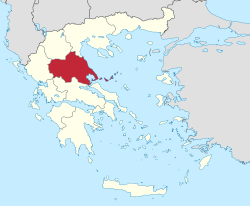
 Thessaly within Greece | |
| Coordinates: 39°36′N 22°12′E / 39.6°N 22.2°E | |
| Country | |
| Decentralized Administration | Thessaly and Central Greece |
| Cession | 1881 |
| Capital | Larissa |
| Port city | Volos |
| Regional units | |
| Government | |
| • Regional governor | Dimitris Kouretas (PASOK – Movement for Change) |
| Area | |
| • Total | 14,036.64 km2 (5,419.58 sq mi) |
| Population (2021)[1] | |
| • Total | 688,255 |
| • Density | 49/km2 (130/sq mi) |
| Demonym | Thessalian |
| GDP | |
| • Total | €9.337 billion (2021) |
| Time zone | UTC+2 (EET) |
| • Summer (DST) | UTC+3 (EEST) |
| ISO 3166 code | GR-E |
| HDI (2022) | 0.880[3] very high · 4th of 13 |
| Website | www |
Thessaly (/ˈθɛsəli/ THESS-ə-lee; Greek: Θεσσαλία, romanized: Thessalía [θesaˈli.a]; ancient Thessalian: Πετθαλία, Petthalía) is a traditional geographic and modern administrative region of Greece, comprising most of the ancient region of the same name. Before the Greek Dark Ages, Thessaly was known as Aeolia (Ancient Greek: Αἰολία, Aiolía), and appears thus in Homer's Odyssey.
Thessaly became part of the modern Greek state in 1881, after four and a half centuries of Ottoman rule. Since 1987 it has formed one of the country's 13 regions[4] and is further (since the Kallikratis reform of 2011) sub-divided into five regional units and 25 municipalities. The capital of the region is Larissa. Thessaly lies in northern central Greece and borders the regions of Macedonia to the north, Epirus to the west, Central Greece to the south, and the Aegean Sea to the east. The Thessaly region also includes the Sporades islands.
- ^ "Census 2021 GR" (PDF) (Press release). Hellenic Statistical Authority. 2022-07-19. Retrieved 2022-09-12.
- ^ "Population on 1 January by age, sex and NUTS 2 region", www.ec.europa.eu
- ^ "Sub-national HDI - Area Database - Global Data Lab". hdi.globaldatalab.org. Retrieved 2021-07-20.
- ^ Π.Δ. (March 6, 1987). Καθορισμός των Περιφερειών της Χώρας για το σχεδιασμό κ.λ.π. της Περιφερειακής Ανάπτυξης [Determination of the Regions of the Country for the planning etc. of the development of the regions]. ΦΕΚ. pp. 51/87.